The Student News Site of Marjory Stoneman Douglas High School

Eagle Eye News

Breaking News
  • April 16School Board of Broward County moves to separate with Dr. Peter Licata and hire Deputy Superintendent Dr. Howard Hepburn for three-year contract
  • April 16Broward Superintendent Dr. Peter Licata announces resignation
  • April 6MSD FEA chapter wins 1st place for most creative fundraiser and 3rd place for membership motivation project and scrapbook competition at county convention
  • April 6WMSD TV Program wins five awards at national STN competition
  • April 3Modified schedule tomorrow, April 4 due to PSD and BEST testing for freshmen and sophomores
The Student News Site of Marjory Stoneman Douglas High School

Eagle Eye News

The Student News Site of Marjory Stoneman Douglas High School

Eagle Eye News

Advertisements

Tropical storm Philippe unexpectedly rips through Florida

Tropical Storm Philippe formed off the coast of Mexico and rapidly made its way to the Atlantic. Photo Courtesy of NASA

As Florida recovers from the onslaught of hurricanes that have hit the state over the course of this hurricane season, a tropical storm made landfall over the weekend.

Winds were first felt on Sat. Oct. 28, but the rain and winds dirt down by Sunday morning. Because of the storm’s speed, there had been very little time for preparation between its formation and its landfall in Florida.

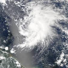
The storm originated in the Caribbean off the coast of the Yucatan Peninsula in Mexico. The storm had a maximum of 40 mph sustained winds, a noticeable decrease compared to the devastating 183 mph winds inflicted by Hurricane Irma.

However, even minor winds and heavy rain can make driving difficult, especially for everyone attending Halloween parties on Saturday night.

“Tropical storm Philippe really caught me off guard because I didn’t know much about it,” said senior Gabriel Ocejo, “Driving home last night the rain was really heavy, but thankfully I got home okay.”

Traveling quickly at 24 mph, nearly triple Irma’s 9 mph, the storm was originally expected to reach Maine by Monday afternoon. Maine is not a typical recipient of tropical storms considering how far north it is, but it is possible it will not be a target at all because the storm is now accelerating away from the mainland and out into the Atlantic. It is forecasted to become a post-tropical cyclone in the next 24 hours.

Leave a Comment
Donate to Eagle Eye News
$655
$1200
Contributed
Our Goal

Your donation will support the student journalists of Marjory Stoneman Douglas High School. Your contribution will allow us to purchase equipment and cover our annual website hosting costs.

Navigate Left
Navigate Right
Donate to Eagle Eye News
$655
$1200
Contributed
Our Goal

Comments (0)

All Eagle Eye News Picks Reader Picks Sort: Newest

Your email address will not be published. Required fields are marked *